Goodwin Fire 2017
The wildfire did burn some of our Mining Claim.
The Game and Fish Officers escorted Buddy and Lana into the claim to retrieve some expensive tools after all evacuations were lifted. It will be some time before they can get back to Prospecting out on the claim. Will post again when that happens!


Originally Published: July 7, 2017 11:36 a.m.
In the meantime we are working on our Travel Trailer. Will post photos of it soon.
Also Cindy is baking up a storm on scones in our new stainless steel kitchen. She is registered with Az Health Dept. in their Home Baked and Confectionery Goods Program!

Thanks for Visiting!
Cin & Bud from Craft Flaire.
The Game and Fish Officers escorted Buddy and Lana into the claim to retrieve some expensive tools after all evacuations were lifted. It will be some time before they can get back to Prospecting out on the claim. Will post again when that happens!


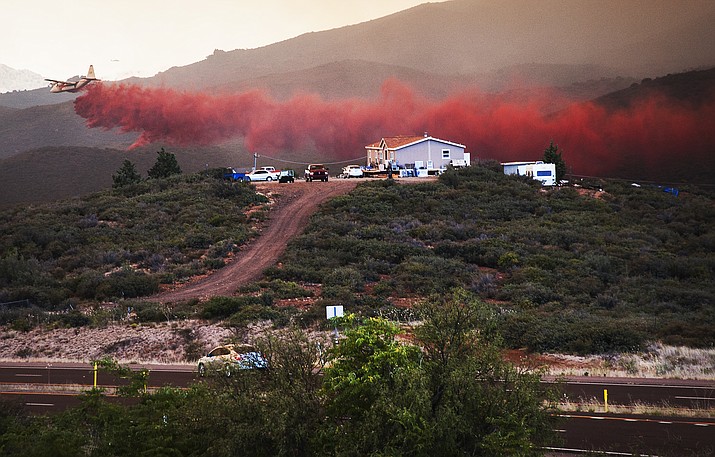
The Goodwin Fire was at 28,516 acres on Friday, July 7, and was 95 percent contained, according to U.S. Forest Service spokeswoman Debbie Maneely.
There are still 159 people working the fire, which started the afternoon of June 24, and the cause is still under investigation.
“In the northwest corner of the Goodwin fire, near Big Bug Mesa, pockets of fuel inside the fire perimeter will continue to burn out and a few isolated, single-tree torching instances are possible, but unlikely to threaten containment lines,” Maneely said. “Crews will continue chipping, fence repair, and scattering of brush on the dozer and handlines.”
The Prescott National Forest Burned Area Emergency Response team has started its initial assessment of the impacts of the fire. The assessment identifies areas of severe burn and potential threats to human life and safety, property, and potential threats to important cultural and natural resources.
Authorities are being vague about how many structures were burned. County and federal officials say they're continuing to assess the losses.
Residents who live downstream from burned areas should be aware that the potential for flooding and debris flow increases after a fire, Maneely said. “Even after prescribed emergency actions are implemented to minimize the post-fire risks, the burned area still poses a risk from potential flooding and debris flows.”
It is important that residents take steps to protect themselves and their property from flooding and mudflows. Residents living near or around a recently burned area should:
• Monitor local weather reports and public safety bulletins, local road closures, emergency notifications, weather alerts, and follow local, county, and city advisories.
• Use a Weather Radio or smart phone weather app— AccuWeather, Weather Channel or WeatherBug. All apps are free and available on both Android and iOS platforms.
• Prepare to evacuate if emergency authorities determine that flooding and mudflows are expected.
Additional flood information is available from the Yavapai County Flood Control District (www.ycflood.com/).
Also Cindy is baking up a storm on scones in our new stainless steel kitchen. She is registered with Az Health Dept. in their Home Baked and Confectionery Goods Program!

Thanks for Visiting!
Cin & Bud from Craft Flaire.

Comments
Post a Comment